

You can find on this page the Sweden region map to print and to download in PDF. The Sweden political map presents states, regions, provinces and surrounding areas of Sweden in Northern Europe.

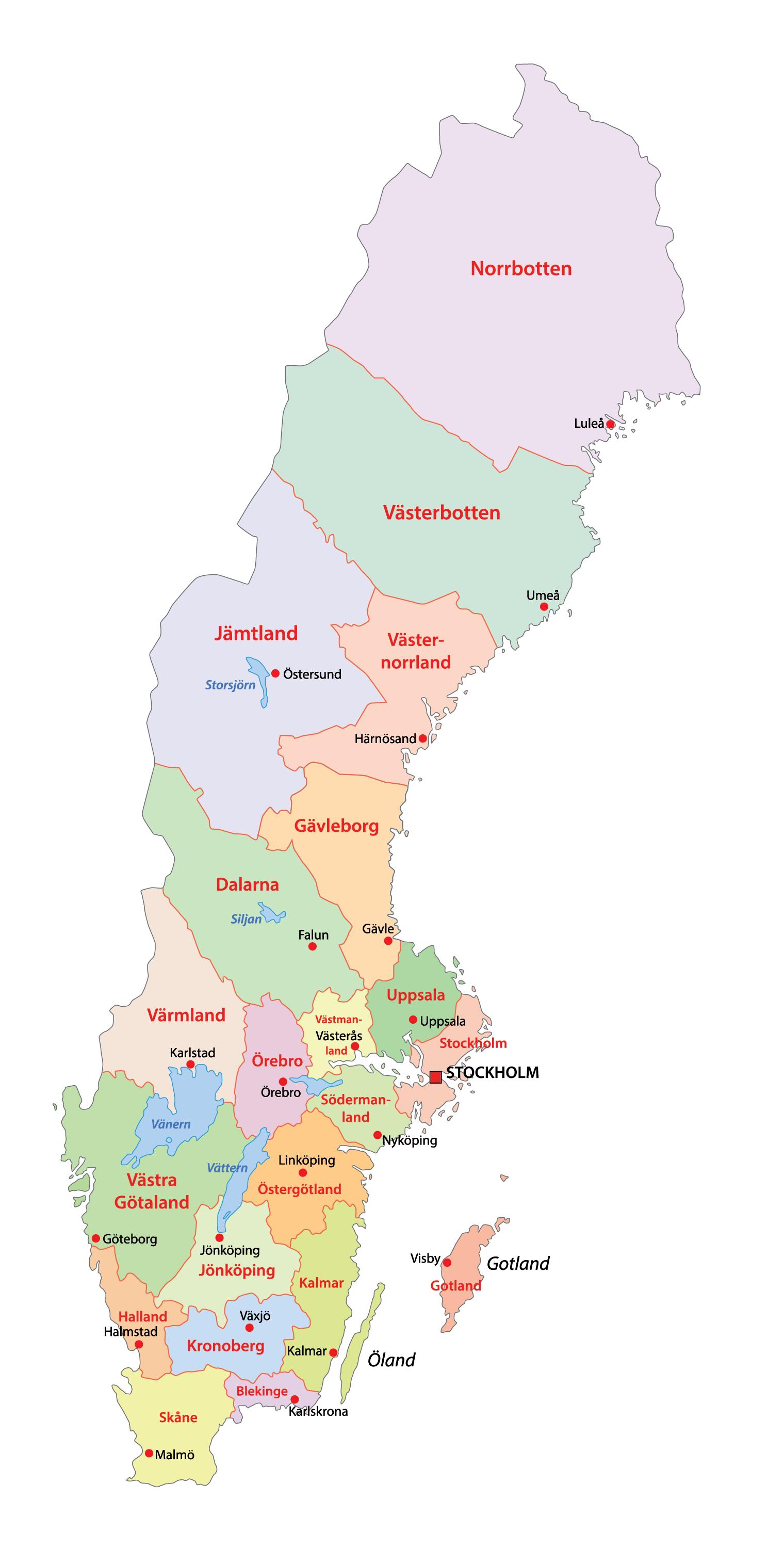
The Sweden regions map shows surrounding areas and provinces of Sweden. This administrative map of Sweden will allow you to know regions of Sweden in Northern Europe. The Sweden regions map is downloadable in PDF, printable and free.
The Counties of Sweden (Swedish: län) are the first level administrative and political subdivisions of Sweden as you can see in Sweden regions map. Sweden is divided into 21 counties or regions. The counties were established in 1634 on Count Axel Oxenstierna initiative, superseding the historical provinces of Sweden (Swedish: landskap) to introduce a modern administration. At that time, they were what the translation of län into English literally means; fiefdoms. The county borders often trail the provincial borders, but the Crown often chose to make slight relocations to suit their purposes. There are controversial proposals to divide Sweden into larger regions, replacing the current counties.
In each county or region there is a County Administrative Board (länsstyrelse) headed by a governor (landshövding) as well as a County Council and several other government organisations as its shown in Sweden regions map. The County Administrative Board is appointed by the Government to coordinate administration with national political goals for the county. The county council or landsting on the other hand is a regional government, i.e. a political assembly appointed by the electorate to deliberate on the municipal affairs of the county, primarily regarding the public healthcare system and also public transport, education and culture. A number of several other government agencies are organised on a county basis, including the main bodies of police, employment, social insurance, and forestry services.
Each county or region in Sweden is further divided into municipalities (kommuner), the existence of which is partly at the discretion of the central government. Since 2004 their number has been 290, thus an average of 13.8 municipalities per county. (See Sweden regions map). Until 1968, the City of Stockholm had its own "county code" A, which is still used interchangeably with AB in some contexts, and County of Stockholm had county code B. L was for Kristianstad County and M was for Malmöhus County but since they were merged to form Scania County, M is usually used. O used to stand for Gothenburg and Bohus County but has been used for West Götaland County since it was merged with Skaraborg County (R) and Älvsborg County (P).
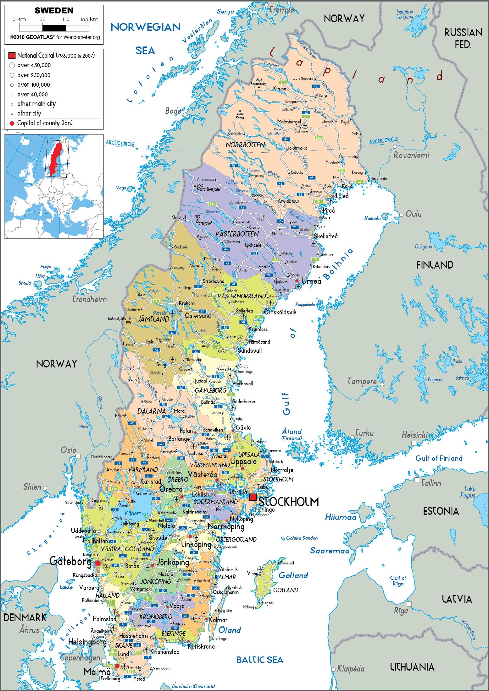
The Sweden political map shows regions and provinces of Sweden. This administrative map of Sweden will allow you to show regions, administrative borders and cities of Sweden in Northern Europe. The Sweden political map is downloadable in PDF, printable and free.
Politics of Sweden takes place in a framework of a parliamentary representative democratic constitutional monarchy as you can see in Sweden political map. Executive power is exercised by the government, led by the Prime Minister of Sweden. Legislative power is vested in both the government and parliament, elected within a multi-party system. The Judiciary is independent, appointed by the government and employed until retirement. The Constitution of Sweden consists of four fundamental laws. The most important is the Instrument of Government of 1974 which sets out the basic principles of political life in Sweden, defining rights and freedoms. The Act of Succession is a treaty between the old Riksdag of the Estates and The House of Bernadotte regulating their rights to accede to the Swedish throne.
Following the general elections held on 17 September 2006, Fredrik Reinfeldt of the Moderate Party was elected Prime Minister of Sweden by the new parliament on 5 October. Together with the three other political parties in the centre-right Alliance for Sweden, Reinfeldt presides over a coalition government as its shown in Sweden political map. The Swedish Social Democratic Party has played a leading political role since 1917, after Reformists confirmed their strength and the revolutionaries left the party. After 1932, the Cabinets have been dominated by the Social Democrats. Only four general elections (1976, 1979, 1991 and 2006) have given the centre-right bloc enough seats in Parliament to form a government. This is considered one reason for the Swedish post-war welfare state, with a government expenditure of slightly more than 50% of the gross domestic product.
Sweden has a history of strong political involvement by ordinary people through its "popular movements" (Folkrörelser in Swedish), the most notable being trade unions, the women movement, the temperance movement, and — more recently — sports movement. Election turnout in Sweden has always been high in international comparisons, although it has declined in recent decades, and is around 82 percent (81.99 in Sweden general election, 2006) as its mentioned in Sweden political map. Some Swedish political figures that have become known worldwide include Joe Hill, Carl Skoglund, Raoul Wallenberg, Folke Bernadotte, Dag Hammarskjöld, Olof Palme, Carl Bildt, Hans Blix, and Anna Lindh.
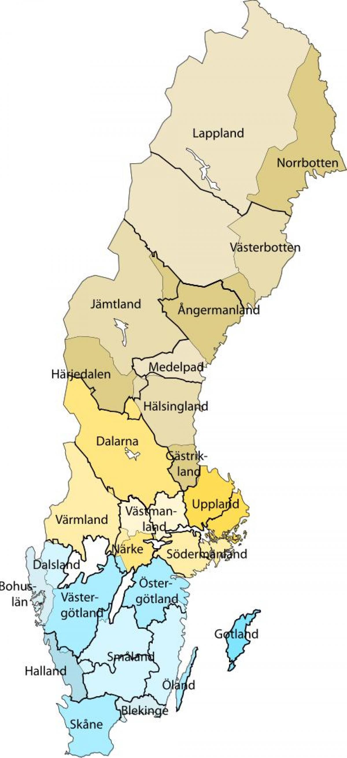
The Sweden states map shows all departments and regions of Sweden. States map of Sweden will allow you to know areas and cities of Sweden in Sweden. The Sweden states map is downloadable in PDF, printable and free.
The states of Sweden, landskap, are historical, geographical and cultural regions. Sweden has 25 states and they have no administrative function, but remain historical legacies and the means of cultural identification as you can see in Sweden states map. Several of them were subdivisions of Sweden until 1634, when they were replaced by the counties of Sweden (län). Some were conquered later on from Denmark–Norway. Others like the states of Finland were lost. Lapland is the only state acquired through colonization. In some cases, the administrative counties correspond almost exactly to the provinces, as is Blekinge to Blekinge County and Gotland, which is a province, county and a municipality. While not exactly corresponding with the province, Härjedalen Municipality is beside Gotland the only municipality named after a province. In other cases, they do not, which then enhances the cultural importance of the states. In addition, the administrative units are subject to continuous changes–several new counties were for instance created in the 1990s–while the provinces have had their historical borders outlined for centuries.
The states of Sweden are still used in colloquial speech and cultural references, The states of Sweden can therefore not be regarded as an archaic concept. The main exception is Lapland where the population see themselves as a part of Västerbotten or Norrbotten, based on the counties. Two other exceptions are Stockholm and Gothenburg, where the population see themselves as living in the city, not in a state, since both cities have state borders through them as its shown in Sweden states map. Since most of the historical Swedish provinces did not have set coats of arms at the time of Gustav Vasa death, they were promptly created and granted. Götaland (Gothia, Gothenland) consists of ten historical states located in the southern part of Sweden. Svealand (Swealand) consists of the following six provinces in middle Sweden. Norrland (Northland) consists today of nine provinces in northern and central Sweden.
Sweden was historically divided into the four lands: Götaland (Sweden), Svealand (Sweden), Österland (Finland), Norrland (Sweden and Finland). Götaland and Svealand consisted before c. 1000 AD of petty kingdoms as its mentioned in Sweden states map. The main tribe of Götaland was the Geats; the main tribe of Svealand was the Suiones (or the "historical Swedes"). Norrland was the denomination for all the unexplored northern parts. Österland (the name had early come out of use) in Finland, was an integral part of Sweden, but was in 1809 annexed by Russia as the Grand Duchy of Finland, to become in 1917 the independent country of Finland. The borders of these regions have changed several times throughout history and Norrland, Svealand and Götaland are only parts of Sweden, a collective of states.